This article is part of “The New Nuclear Age,” a special report on a $1.5-trillion effort to remake the American nuclear arsenal.
Last March the U.S. Air Force released a two-volume, 3,000-plus-page report detailing the environmental impact of its plans to replace all 400 “Minuteman” land-based intercontinental ballistic missiles (ICBMs) with new “Sentinel” missiles by the mid-2030s. The program is part of a $1.5-trillion effort to modernize the U.S. nuclear arsenal and its command-and-control infrastructure. The report, required by the National Environmental Policy Act of 1970, covers the “potential effects on the human and natural environments from deployment of the Sentinel system” and from, among other things, the refurbishing of existing missile silos and the construction of new utility corridors and communications towers. But it doesn’t mention the most significant risks to surrounding communities—namely, what happens if these missiles, which are intended to serve as targets for enemy nuclear weapons, are ever attacked.
The original purpose of the land-based missile system was to deter an enemy nuclear attack by threatening prompt and devastating retaliation, but a key argument for the continued existence—and now the replenishment—of the land-based missiles is to provide a large number of fixed targets meant to exhaust the enemy’s resources. Since 1962, when the first ICBMs were installed in the U.S. heartland, competition from other legs of the nuclear triad has forced the rationale for land-based weapons to evolve. By the 1970s, when the U.S. Navy deployed long-range submarine-launched ballistic missiles, the air force had placed 1,000 Minutemen in silos across seven states. As missile-guidance systems improved, it soon became clear that the land-based weapons were vulnerable to attack because of their fixed locations, whereas the stealthy sea-based weapons were much better protected.
The air force used the vulnerability of the land-based missiles to argue for their necessity. In 1978 General Lew Allen, Jr., then air force chief of staff, proposed that the silos offered “a great sponge” of targets in the U.S. to “absorb” incoming Soviet nuclear weapons. Destroying the missile fields would require such a massive attack that adversaries couldn’t manage it or even contemplate it. Absent the land-based missiles, the argument goes, an adversary would have far more resources available to seek out and attack other U.S. military and infrastructure targets or even cities.
Even if an adversary is rational enough to not initiate a full-scale attack, the land-based missiles greatly increase the risk of accidental nuclear war. To preclude the possibility of enemy weapons destroying the missiles in their silos, the air force maintains the fleet on high alert, ready to launch on an order from the president—within minutes of enemy missile launches being detected. This “launch on warning” posture makes land-based missiles the most destabilizing leg of the U.S. nuclear triad (which also comprises the missiles based on aerial bombers and submarines). During the cold war there were several false alarms about enemy attacks. If a similar error precipitates the launching of the ICBMs, the adversary will almost certainly retaliate by launching its own nuclear arsenal at military, industrial and demographic targets in the U.S.
Attacking a missile silo requires detonating one or two nuclear warheads, with explosive yields equivalent to 100,000 tons of TNT, close to the buried target. The resulting nuclear explosions will generate gargantuan fireballs that will vaporize everything in their surroundings and produce destructive shock waves capable of wrecking the missiles in their launch tubes. Because the warheads will detonate close to the ground, the nuclear fireballs will suck in soil and other debris and mix it with radioactive bomb effluents as they rise in the air. About 10 minutes after detonation, the mixture of debris and fission products will form miles-high radioactive mushroom clouds, which will then be dispersed by high-altitude winds, leading to fallout on downwind areas.
Studies of the projected fallout from a nuclear attack on the missile fields, published in Scientific American in 1976 and 1988, showed that radioactive particles could travel hundreds of miles downwind. A 1990 guide from the Federal Emergency Management Agency on risks and hazards from natural and nuclear calamities confirmed these assessments, adding that no locality in the U.S. was free of the risk of receiving deadly levels of radiation. Today FEMA’s publications about the effects of nuclear explosions focus on single nuclear detonations; the agency no longer publishes countrywide assessments of risks from nuclear attacks.
All these past studies relied on relatively simple fallout models and average seasonal winds. Current computational capability, along with higher resolutions in archived weather data, allows scientists to map the radiological risk from a preemptive nuclear attack on the missile silos in unprecedented detail. The results of my simulations, presented here for the first time, paint a harrowing picture of the potential consequences of living with these weapons for the foreseeable future.
According to my models, a concerted nuclear attack on the existing U.S. silo fields—in Colorado, Wyoming, Nebraska, Montana and North Dakota—would annihilate all life in the surrounding regions and contaminate fertile agricultural land for years. Minnesota, Iowa and Kansas would also probably face high levels of radioactive fallout. Acute radiation exposure alone would cause several million fatalities across the U.S.—if people get advance warning and can shelter in place for at least four days. Without appropriate shelter, that number could be twice as high. Because of great variability in wind directions, the entire population of the contiguous U.S. and the most populated areas of Canada, as well as the northern states of Mexico, would be at risk of lethal fallout—more than 300 million people in total. The inhabitants of the U.S. Midwest and of Alberta, Saskatchewan, Manitoba and Ontario in Canada could receive outdoor whole-body doses of radiation several times higher than the minimum known to result in certain death.
Even if there is no nuclear war, people in communities near the missile fields will continue to face serious risks that are also not discussed in the environmental impact statement. One is the accidental release of radioactive materials, such as plutonium, in the warheads by a mechanical shock, fire or explosion. A second is the accidental detonation of a warhead leading to a nuclear explosion. The history of the U.S. nuclear missile program provides several examples of silos or missiles catching fire and of missiles exploding in their launch tubes. One time, in 1964, a warhead fell from the top of its missile to the bottom of its 80-foot-deep silo. Nuclear weapon accidents are not always discussed publicly. The air force hasn’t disclosed, for example, the nature of a 2014 “mishap” that occurred while personnel were troubleshooting a Minuteman. The episode caused $1.8 million in damages to the missile, which had to be removed from its silo.
The air force needs to be far more transparent about the true risks of its land-based nuclear missile fleet so the U.S. public can make informed decisions about living with this danger for another half a century.
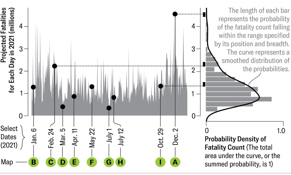
How Fallout and Fatalities Shift with the Winds
A concerted nuclear attack on the missile silos in the U.S. heartland would generate radioactive dust that travels with prevailing winds. Sébastien Philippe and his colleagues at Princeton University’s Program on Science and Global Security used archived weather data to simulate the paths of the resulting plumes for 48 hours, by when most of the dust settles. Because wind directions change daily, the researchers computed fallout dispersal from an 800-kiloton warhead detonating simultaneously at each of 450 silos on any given day of 2021. The selections below (A–I) demonstrate the variability of wind directions and, consequently, of the doses of outdoor radiation received over four days of exposure to radioactivity. The scientists further combined these simulations with data on population density and building height to calculate the resulting fatalities. Someone absorbing four grays (equivalent to four joules of radiation energy per kilogram of body weight) would have a 50 percent chance of dying, but people sheltering in bigger buildings would receive smaller doses. Depending on wind directions, a nuclear attack on the missile silos could kill several million people.
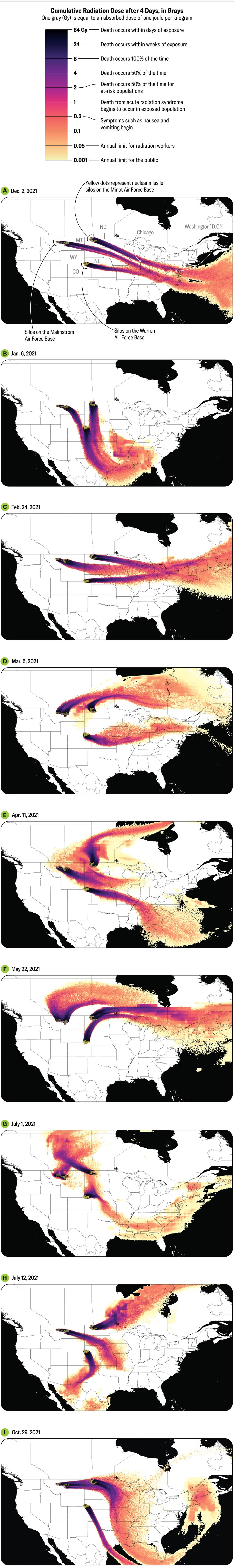
Fatality Count: For a simulated attack on any day of 2021, the scientists computed the resulting fatalities. The chart shows the impact of variable wind directions on the estimated fatalities after four days of exposure. The estimates range from 340,000 (for an attack on July 1) to 4.6 million (on December 2). The average estimated death toll is 1.4 million. The curve shows the probability (technically, probability density) of the number of fatalities specified on the vertical axis.
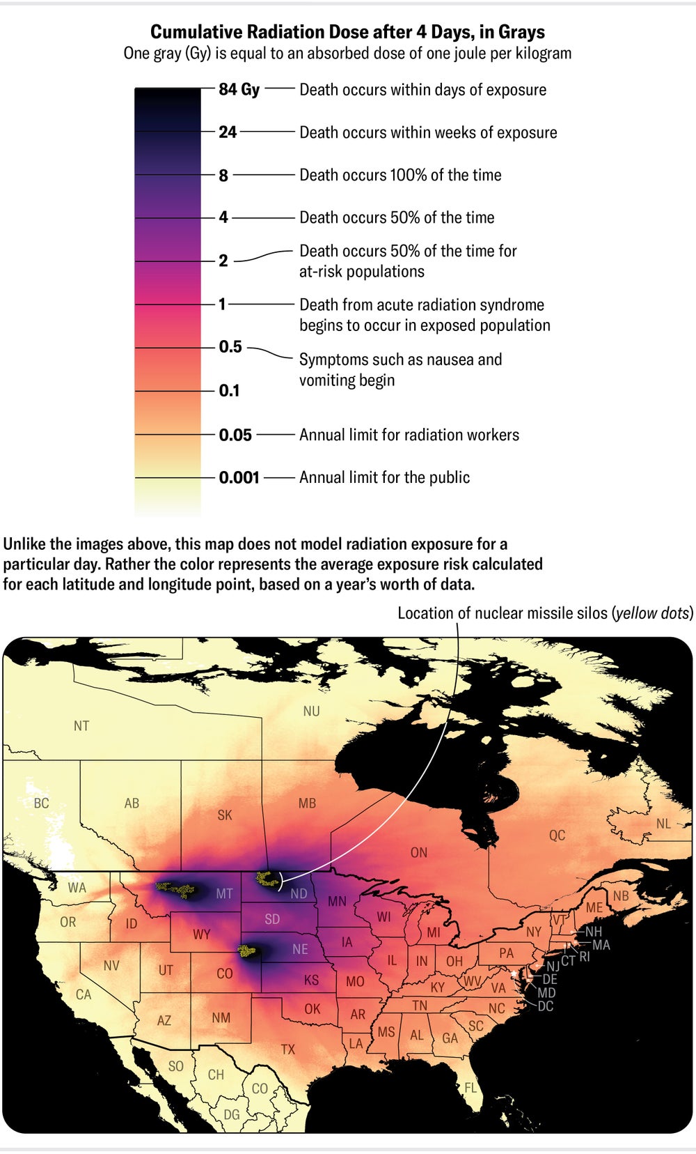
WHICH LOCATIONS ARE THE RISKIEST?
To calculate the average risk of radiation exposure at any given location in North America from a nuclear attack on the silo fields, Philippe and his co-workers summed the simulated outcomes for any day of 2021 (preceding graphic) and divided by 365. They thereby averaged the impact of shifting winds on radioactive fallout across the continent. This map shows the average outdoor radiation dose across North America after four days of exposure. Communities living closest to the silos could receive several times more than 8 Gy, which scientists regard as lethal. Most inhabitants of Montana, North Dakota, South Dakota, Nebraska and Minnesota would get average doses greater than 1 Gy, causing fatalities from acute radiation syndrome, especially among children. The U.S. population would receive average doses greater than 0.001 Gy per year, which is the current annual limit for exposure to the public.
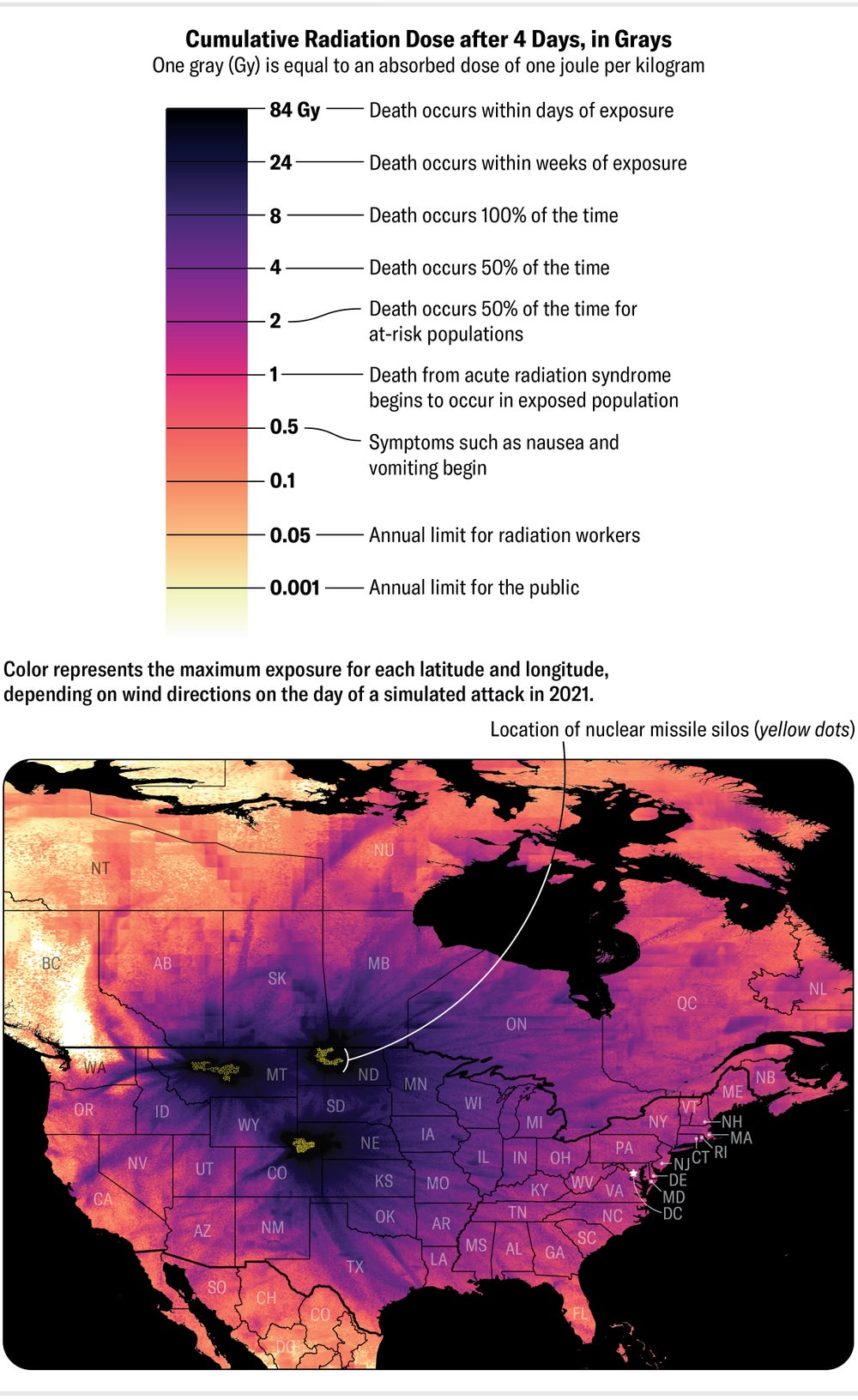
THE WORST-CASE SCENARIOS
Sifting through simulations for each day of 2021, the Princeton researchers computed the worst possible outcome at each location from a concerted nuclear attack on the missile silos. This map shows all the worst-case scenarios across North America. Not all locations would experience the worst outcome from the same attack; which areas would be impacted depends on wind patterns on the day of the attack. Overall, most people in North America live in areas with about a 1 percent chance of receiving an outdoor dose greater than 1 Gy. The chance of getting a lethal dose escalates closer to the silos, with three million at risk of receiving 8 Gy or more. These simulations make no assumptions about access to health care or emergency services. Nor do they include other sources of exposure such as immediate radiation from nuclear explosions.
Source link
